Greater Brisbane key corridors performance January-June 2017
Greater Brisbane road network
This report provides information on the traffic volume and average speed for the Greater Brisbane key transport corridors over the January to June 2017 period. The corridors include Brisbane City Council (Council) and Department of Transport and Main Roads (TMR) managed roads.
Network summaries are presented in vehicle kilometres travelled (VKT) and average network speeds. The report includes information on initiatives being undertaken by both organisations to manage congestion on the road network.
Report findings
There are 38 key corridors, comprising 317.2 kilometres of road, in the Greater Brisbane area. Council manages 18 of these corridors, equating to 102.1 kilometres of road and TMR manages the other 20, equating to 215.1 kilometres of road.
Network vehicle kilometres travelled increased by 12.5% from the same period last year.
| Peak average network speed details | Speed |
|---|---|
Weekday AM peak average network speed is 42.0 km/h:
|  |
Weekday PM peak average network speed is 42.1 km/h:
|  |
- Bruce Highway (managed by TMR) is the busiest corridor with an average daily volume of 156,195 vehicles per day.
- Cleveland Redland Bay Road (managed by TMR) is the least busy with 20,012 vehicles per day.
- In the AM peak, March saw the lowest average speed at 38.86 km/h, while January had the highest average speed at 45.61 km/h
.
- In the PM peak, May had the lowest average speed at 40.21 km/h, with January having the highest average speed at 45.0 km/h.
- In the AM peak, Centenary Motorway* (managed by TMR) is the fastest at an average speed of 76.49 km/h (100 km/h speed limit); the slowest is Stanley Street (managed by Council) at 16.83 km/h (speed limit is 60 km/h with a school zone speed of 40 km/h on this corridor).
- In the PM peak, Centenary Motorway* (managed by TMR) is the fastest at 96.05 km/h (100 km/h speed limit) and the slowest is Stanley Street (managed by Council) at 22.93 km/h (speed limit is 60 km/h with a school zone speed of 40 km/h on this corridor).
- Compared with the same period in 2016, AM peak average speed on Council’s 18 key corridors decreased by 1.54 km/h (5.13%) from 28.94 km/h to 27.4 km/h. PM peak average speed decreased by 2.09 km/h (6.01%) from 34.7 km/h to 32.61 km/h.
- Compared with the same period in 2016, AM peak average speed on TMR’s 20 key corridors decreased by 0.09 km/h (0.04%) from 46.19 km/h to 46.10 km/h. PM peak average speed decreased by 0.37 km/h (0.76%) from 45.19 km/h to 44.82 km/h.
Centenary Motorway*: Between Logan Motorway and Ipswich Motorway
Compiled by Council, with data and analysis jointly undertaken by Council and Department of Transport and Main Roads. Incident data provided by the Brisbane Metropolitan Transport Management Centre (BMTMC).

Greater Brisbane key corridors
Note: Speed data for the January – June 2016 period was not available for corridor: 13c – Moggill Road (2) and speed data for the January – June 2017 period was not available for corridor: 9b – Old Northern Road.
Network vehicle kilometres travelled summary
Average vehicle kilometres travelled of 38 key corridors by month
Traffic volume and vehicle kilometres travelled
All traffic volume data takes into account both directions of travel and includes weekdays only and excludes public holidays. Traffic volumes on TMR’s corridors were taken at the road segment with the highest volume. Council corridor traffic volumes were taken in the middle segment of the corridors.
The average daily traffic volume for the month is the number of vehicles utilising the corridor per day, averaged over all weekdays of the month (excluding public holidays).
AM peak period for TMR corridors is from 6am to 9am as the TMR network is utilised earlier, particularly on the outer edges of the Greater Brisbane road network (for example, the Bruce Highway and the Pacific Motorway). AM peak period for Council corridors is from 7am to 9am. PM peak periods are the same for both TMR and Council corridors, 4pm to 7pm. The monthly AM and PM peak per hour traffic volumes are the average hourly volume for the month over the corresponding AM and PM peak periods, respectively.
Vehicle kilometres travelled (VKT) is a measure of traffic demand on the road network. It is the length of a section of road in kilometres multiplied by the average traffic volume on that section. The daily VKT is the product of the length of the road and average daily traffic (ADT). The monthly VKT is the daily VKT multiplied by the number of days in the analysis period.
The AM peak monthly VKT is the product of the length of the road, the average AM peak hourly traffic volume and number of days in the analysis period.
The PM peak monthly VKT is the product of the length of the road, the average PM peak hourly traffic volume and number of days in the analysis period.
The network VKT is the sum of all the corridors in the network.
Greater Brisbane network vehicle kilometres travelled January to June 2016 and 2017
Council network vehicle kilometres travelled January to June 2016 and 2017
TMR network vehicle kilometres travelled January to June 2016 and 2017
Average network speed summary
Average speed of 38 key corridors
Average speed in kilometres per hour is a measure of traffic efficiency on the road network.
Average speed is calculated using travel times collected from TMR’s and Council’s extensive network of Bluetooth scanners within the Greater Brisbane road network. Average corridor speed includes delays at signalised intersections.
Average travel times were collected during the AM and PM peak periods to calculate the average speed of the corridor. Peak periods are similarly defined as in the VKT calculations. AM peak travel time is taken as the inbound direction while the PM peak travel time is the outbound direction.
Greater Brisbane network average speed January to June 2016 and 2017
Council network average speed January to June 2016 and 2017
TMR network average speed January to June 2016 and 2017
State Government Congestion Initiatives
Department of Transport and Main Roads (TMR) has a number of policies, strategies and projects which are addressing traffic congestion and journey reliability in Greater Brisbane, including those listed below.
- Travel options and travel information – creating a public transport and active transport network that has greater accessibility, frequency and reliability (ongoing funding of principal cycle network, QLDTraffic website and smartphone app, real time-bus information, enhanced train timetable). QLDTraffic was launched in February 2017, providing dynamic and real-time travel information through a new website https://qldtraffic.qld.gov.au/ and a smartphone app.
- Development of a Smarter Solutions: Network Optimisation Framework to help identify low-cost and non-infrastructure solutions that effectively respond to capacity and reliability constraints across Queensland’s transport network and within our current fiscal environment.
- Improved incident management including traffic response units (with Council).
- Signal network optimisation.
- Managed motorway operations (for example, South East Freeway ramp signalling, Ipswich Motorway Lane Use Management, Port of Brisbane Variable Speed Limit operations and Bruce Highway ramp signals and variable speed limits).
- The development of tools to quantify excessive congestion (accepting that a certain level of congestion is inevitable), and using this to prioritise possible upgrade to the network (intersection and route ranking), and quantify the causes of congestion. This tool will assist transport planning and road operations.
- State-wide rollout of Emergency Vehicle Priority on state-controlled roads.
- Improved traffic management at roadworks.
- Using Queensland Government's Project Assurance Framework in investment decision-making to maximise the benefits returned to government from project investments.
- Increased capacity – there have been significant projects to address the growing traffic demands on the road network such as Gateway Upgrade North and Ipswich Motorway.
Gateway Upgrade North (GUN)
This $1.143 billion project will ease congestion and improve safety on one of Queensland’s busiest motorways. Once completed, the project from Nudgee to Bracken Ridge will increase capacity and freight efficiency along this important corridor.
Carrying more than 83,000 vehicles a day, the Gateway Motorway North experiences high levels of congestion. The project will not only improve travel time reliability, but also improve safety and increase efficiency of the city’s motorway network and connectivity to key urbanised areas.
In particular, the Deagon section has a poor traffic incident record and a high number of merge/weave movements, highlighting the need for significant safety improvements.
The upgrade aims to benefit the community by improving motorist safety, reducing congestion and accommodating future traffic growth.
This project will upgrade the motorway from four to six lanes between Nudgee and Deagon, with additional pavement rehabilitation and safety works through to Bracken Ridge. It also includes reconfiguring the Nudgee interchange, construction of a new off-road cycle path connecting to local networks, widening of the Deagon Deviation to two lanes in each direction between Depot and Bracken Ridge Roads, and providing of a grade-separated interchange between the Gateway Motorway and the Deagon Deviation at Deagon.
Early works began in 2014, and major construction activities commenced in early 2016. This project is scheduled for completion in late 2018.
The Gateway Upgrade North project is jointly funded by the Australian Government ($914.18 million) and Queensland Government ($228.54 million) on a 80:20 split. The upgrade is being delivered by TMR, with Transurban Queensland engaged to assist in managing the delivery of the major works package.
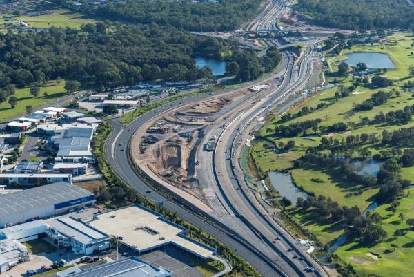
Ipswich Motorway: Rocklea to Darra – Stage 1
The project upgrades a three kilometre section of the Ipswich Motorway from Granard Road, Rocklea to Oxley Road, Oxley. This is the next most critical section of the remaining seven kilometres of the Ipswich Motorway still to be upgraded. More than 85,000 vehicles use the motorway daily including 12,000 commercial vehicles.
This section is a very constrained corridor, passing through high-density commercial industrial precincts. The project will include upgrading three kilometres of the motorway from four to six lanes, constructing higher bridges over Oxley Creek and a new southern service road connection from Boundary Road to Factory Road.
Works will be staged to effectively manage the upgrade of the motorway while under live traffic conditions. The project will improve traffic flow and reduce congestion creating more reliable, consistent travel times. It will also improve safety, local connectivity and flood immunity.
Queensland based Bielby Hull Albem Joint Venture was awarded the design and construction contract on 21 April 2017. The project has now entered into detailed design with construction expected to start in October 2017. Construction is expected to be completed by late 2020.
The Australian and Queensland Governments have committed funds for the $400 million upgrade on a shared basis.
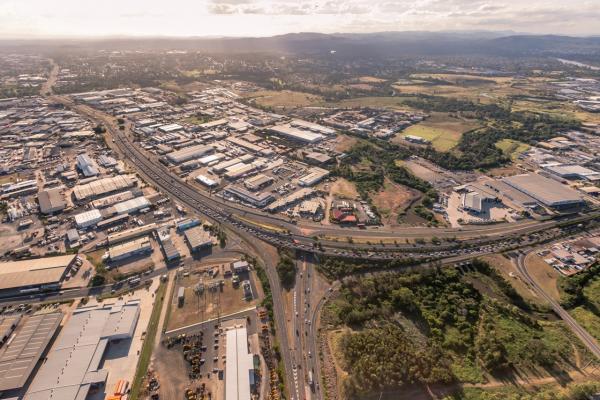
Variable Speed Limit Signs – Western Freeway (Outbound)
The Department of Transport and Main Roads (TMR) will be installing Variable Speed Limit signs (VSLS) along a 4 km stretch of the Western Freeway (outbound), between Waverley Road Overpass and Figtree Pocket Road Overpass.
TMR is taking steps to reduce the potential of accidents and reduce congestion for the 37,000 road users who travel this Western Freeway section daily.
This section of road experiences a high level of congestion during afternoon peak and would greatly benefit from VSLS. VSLS will change speed in gradual steps to optimise flow and improve travel time.
Safety benefits will include the reduction of secondary incidents (rear end crashes).
New VSLS will be installed at the following six locations:
- after Waverley Road Overpass
- near Moggill Road off-ramp
- on Moggill Road on-ramp
- after Russell Terrace / Moggill Road on-ramp
- after Jerrang Street Overpass
- on Figtree Pocket Road on-ramp
The construction cost is estimated to be $1 million. The installation will commence in second half of 2017 and is expected to be completed by the end of 2017.
Corridor Signal Optimisation Project
TMR is reviewing the traffic signal coordination of key arterial routes that have the potential for improvement. The intended benefit is to improve travel times along TMR’s key corridors across various times of the day. The review consists of collecting up-to-date traffic data and conducting an optimisation analysis using advanced traffic modelling software.
The section of Sandgate Road, between Junction and Roghan Roads was reviewed in 2016 and new traffic signal plans were developed. These plans were implemented progressively between April and October 2016, improving the performance of the corridor.
Travel time along this corridor before and after the implementation was compared as part of the evaluation process. Analysis showed that travel time saving of one minute was found on average in the direction of peak hour travel. A maximum of two minutes travel time saving was observed in the busiest times of the day, which is equivalent to 10 per cent improvement in travel time.
The next key route for review is Stafford Road, between Appleby Road and Richmond Street. The review is expected to be completed in the 2017-18 financial year.
Council congestion initiatives
Major Projects
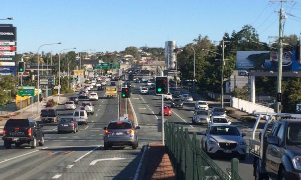
Council is taking real action to tackle traffic congestion and get residents home quicker and safer. Through a network-wide focus on traffic improvements, Council is ensuring our city has the infrastructure it needs to meet current demand, as well as the needs of future generations.
This means building an improved road and transport network across Brisbane through a range of projects including major road construction and intersection upgrades. Council is also working to minimise traffic congestion and improve safety in local areas through intersection and corridor upgrades and minor road projects.
A selection of road projects are profiled below.
Profile: Telegraph Road Stage 1B
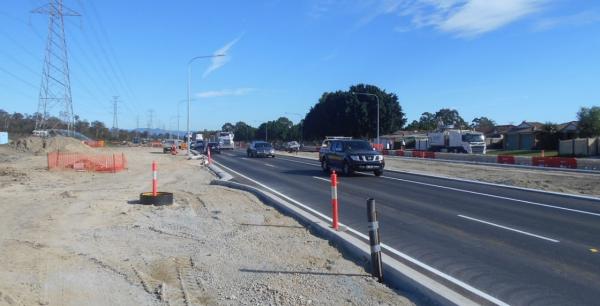
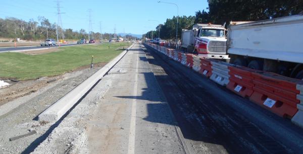
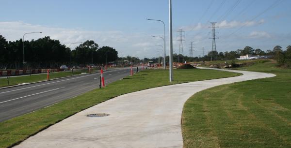
The Telegraph Road corridor upgrade Stage 1B (Norris Road to Mustang Street) is jointly funded by the Australian Government and Brisbane City Council. The project caters for existing and future traffic demands, ensuring we have the infrastructure in place to meet the needs of future generations.
Works undertaken to date include:
- electrical works on the southern side of Telegraph Road, including installation of conduits and poles for new LED street lights and new traffic signals at Mustang Street (signals will become operational at the end of the project)
- drainage works on the southern side of Telegraph Road
- earthworks on the southern side of Telegraph Road, including installation of subsoil drains
- installation of kerb and channel on the westbound carriageway
- asphalting and temporary line marking works to prepare the new westbound carriageway for traffic
- installation of a leachate management system to capture and manage flow of leachate from the landfill site at Bill Brown Sports Reserve
- switch-over of traffic to the new westbound carriageway to enable works to begin on excavating and reconstructing the existing roadway on the northern side of Telegraph Road
- landscaping works on the southern side of Telegraph Road (ongoing)
- commissioning of traffic signals at Mustang Street
- completion of the new three-metre-wide shared path on the southern side of Telegraph Road
- completion of landscaping on the southern side of Telegraph Road
- removal of asphalt and kerb on the northern side of Telegraph Road, installation of final layers of asphalt and line marking on the east and westbound carriageways of Telegraph Road
- replacement of footpath on the northern side of Telegraph Road
- works to reinstate driveways on the northern side of Telegraph Road.
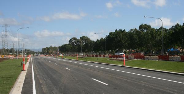
Profile: Telegraph Road Corridor Stage 2
Stage 2 of the Telegraph Road and Lemke Road corridor upgrade project will support growth in the northern suburbs by improving access to major transport corridors to the north and south including the Gateway Motorway and Gympie Arterial Road/Bruce Highway. It will also deliver active transport infrastructure along the length of Telegraph Road and sections of Lemke Road and Depot Road, making walking and cycling safer and easier for residents.
The project will connect directly to Stage 1B (Norris Road to east of Mustang Street) at its western end and with the Depot Road upgrade being delivered as part of the Gateway Upgrade North (GUN) project at its eastern end.
Project features
The Stage 2 upgrade involves:
- improving freight and general traffic movement
- improving safety for all modes of traffic
- reducing traffic congestion
- increasing capacity to accommodate existing and future traffic demands including those associated with the Gateway Upgrade North (GUN) project
- improving travel time reliability for all modes of traffic
- providing improved facilities for cyclists and pedestrians
- addressing existing deficiencies in the local road arterial network (Local Road of Regional Significance)
- supporting economic development in the region by facilitating better movement of freight from the Brendale industrial area to the Gateway Motorway and beyond and connecting residents to employment hubs
- improving flood immunity on Lemke Road, particularly at the Cabbage Tree Creek crossing.
Background
Telegraph Road forms part of the North Brisbane arterial road network and is a Local Road of Regional Significance (LRRS). It provides an important east-west link with the motorway network including routes to the north via Gympie Arterial/Bruce Highway and to the Australia Trade Coast, Port of Brisbane and Brisbane Airport via the Gateway Motorway. The corridor also has a significant role in carrying freight and supports the movement of commercial traffic from the Brendale industrial area to the motorway network for access to the port and markets.
The commencement of the Australian and State Government funded GUN project by TMR and the planned access changes associated with this project will result in a significant increase in traffic demand. This creates a need for accelerated delivery of the upgrade between Mustang Street and the Gateway Motorway on/off ramps (Stage 2).
Stage 2 includes:
- constructing a four-lane median-divided carriageway along Telegraph Road from Mustang Street to the Gateway Motorway on and off ramps and along Lemke Road south to Tallowwood Place, with additional through lanes and turning lanes at intersections
- removing the roundabout at the Telegraph Road, Depot Road and Lemke Road intersection and installing traffic signals
- constructing a four-lane bridge at Cabbage Tree Creek with one in 100 year flood immunity
- providing U-turn facilities for eastbound traffic at the intersection of Telegraph Road and Denham Street and for westbound traffic on Depot Road at the Quinlan Street intersection
- constructing shared pathways on the southern side of Telegraph Road and Depot Road and on Lemke Road, linking to Cabbage Tree Creek Bikeway
- upgrading the cyclist/pedestrian underpass in Depot Road and constructing on-road bike lanes on Telegraph Road, Depot Road and a section of Lemke Road
- installing new light-emitting diode (LED) street lighting on Telegraph Road, Depot Road and Lemke Road
- installing fauna movement measures including a fauna underpass and glider poles
- undergrounding power lines on the southern side of Telegraph Road and Depot Road between Denham Street and Gateway Motorway on and off ramps
- landscaping and revegetation works
- preserving the road corridor for future widening of Telegraph Road to six lanes
- installing yellow stopping lines on both sides of Telegraph Road, Depot Road and Lemke Road within the project scope to facilitate safe traffic flow.
Stage 2 works delivered to date:
- completed detailed design of the Stage 2 upgrade
- identified environmental permit requirements and obtained the necessary permits for the project
- finalised services relocation requirements including execution of relocation agreements
- temporary relocation of services impacting the removal of contaminated materials for the Lemke Road bridge construction
- completed procurement and appointed contractor to undertake the works
- completed land purchase/acquisition required for completion of the project
- commenced construction activities on site
Council will continue with construction activities on site with works to be completed late 2018, weather and construction conditions permitting.
Major Traffic Improvements - Intersections
Profile: Creek Road, Tick Street and Greenmeadow Road intersection upgrade
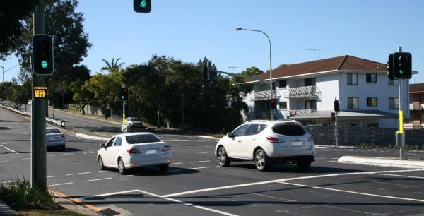
In May 2017, Council completed an upgrade of the Creek Road, Tick Street and Greenmeadow Road intersection at Mount Gravatt East.
Creek Road is a major urban corridor and the intersection with Tick Street and Greenmeadow Road provides access to up to 500 residential properties and businesses.
The project included:
- installing new traffic signals at the intersection
- extending the left-turn pocket out of Greenmeadow Road
- installing bike stand-up lanes on Creek Road
- creating signalised pedestrian crossings across three legs of the intersection.
The upgraded intersection offers improved accessibility and traffic flow, and enhanced motorist, cyclist and pedestrian safety.
This project was jointly funded by Council and the Queensland Government through the Transport Infrastructure Development Scheme. Construction started in early February 2017 and was completed in May 2017.
Profile: Lytton Road, Apollo Road and Thorpe Street intersection upgrade
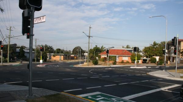
The intersection of Lytton Road, Apollo Road and Thorpe Street, Bulimba was upgraded to provide a signalised intersection, improving traffic efficiency and safety for all road users.
Lytton Road is a suburban road that provides through traffic flow and east-west connection between Bulimba and Morningside. It carries approximately 16,000 vehicles per day with approximately 5% heavy vehicles. Apollo Road is a district road that provides public transport access (bus and ferry) and services approximately 1000 households. It carries approximately 6000 vehicles per day with up to 5% heavy vehicles.
The installation of traffic signals provides controlled pedestrian crossing facilities and enhanced vehicular access into and out of Apollo Road and Thorpe Street. The upgrade aligns with future planning for the area and demonstrates Council's commitment to improving traffic flow and access along major roads.
The project involved:
- installing new traffic signals and pedestrian crossings at the intersection
- installing new on-road bike lanes to replace the existing Bicycle Awareness Zone (BAZ) on Lytton Road
- constructing new footpaths and kerb ramps
- installing a new centre median on Lytton Road, between the intersection and Baldwin Street, to protect the right turning pocket
- altering access into Baldwin Street to be left-in, left-out only
- road resurfacing and new line markings to align to the upgraded intersection configuration
- some minor landscaping.
Construction started in February 2017 and was completed in late June 2017.
Congestion Busting Projects
Arterial Road Program (ARP)
Council's Arterial Road Program (ARP) delivers low-cost, high-impact projects to reduce traffic congestion across Brisbane.
The ARP uses reputed traffic signal intersection modelling software, SIDRA, as the primary decision-making tool to determine the net economic benefits (value for money) for project works undertaken.
The following case studies look at two types of projects delivered from this program. The first type reconfigures existing road space by making changes to line markings, medians and signage. The second type involves the construction of additional road space on the network to achieve minor road widening or lengthening.
CASE STUDY: Road space reconfiguration
Example: Learoyd Road at Paradise Road, Acacia Ridge
Learoyd Road and Paradise Road are arterial roads connecting Blunder Road, Beaudesert Road and the Logan Motorway. They provide an important link between Brisbane's southern suburbs.
The intersection of Learoyd Road and Paradise Road is an offset four-way signalised intersection carrying in the order of 28,000 vehicles per day with approximately 2400 vehicles per hour in peak hours. Both roads are categorised as primary freight accesses and the posted speed limit is 70km/h.
The ARP determined the congestion on Learoyd, caused by the turning demand from Learoyd Road into Paradise Road exceeding the available right turn lane storage, could be addressed by extending the right turn lane from the existing 45 metres to 125 metres.
There was sufficient road space on Learoyd Road to shave the existing median island and create a 125-metre right-turn lane for vehicles turning right from Learoyd Road into Paradise Road. This project also involved civil works to relocate two street lighting poles and associated works for underground services.
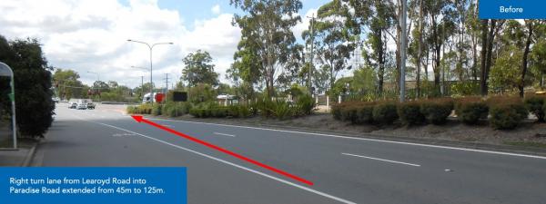
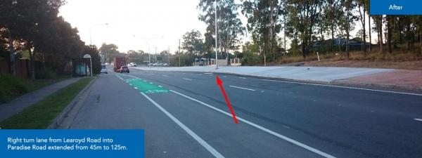
This low-cost, high-impact project was delivered in May 2017 for approximately $450,000.
Council's Bluetooth data shows the project has been successful in reducing congestion on this segment of road, by measuring travel time between the intersections of Learoyd Road with Paradise Road and Learoyd Road with Beaudesert Road.
The project has resulted in a 2.5% improvement in travel time for motorists passing through this intersection every day in the AM peak, and 6.9% for the PM peak.
The table below highlights other reconfiguration projects delivered over the reporting period and the corresponding improvements in travel times.
Road space reconfiguration projects for January to June 2017
Street location | Suburb | Project description | Completed | Improvement (%) |
|---|---|---|---|---|
Coonan Street at Riverview Terrace | Indooroopilly | Extended the right turn lane from Coonan Street to Riverview Terrace | Mar 2017 | 5% |
Gailey Road at Heroes Avenue | Taringa | Created a 25m right turn pocket from Gailey Road southbound into Heroes Avenue | Jan 2017 | 10% |
Handford Road between Pretoria Street and Coxen Street | Zillmere | Provided a second northbound lane on Handford Road | Jun 2017 | 8% |
Mains Road at McCullough Street | Sunnybank | Extended the existing second right turn lane from Mains Road south approach into McCullough Street | Mar 2017 | 9% |
Oxley Road at Cook Street | Oxley | Provided dedicated westbound right turn lane on Oxley Road | Feb 2017 | 1% |
CASE STUDY: Road space construction
Example: Compton Road at Gowan Road, Stretton
Compton Road is classified as an Arterial Road under Council's Road Hierarchy as well as being a Primary Freight Route. It provides an important link between western and eastern suburbs and connectivity between other major arterials such as Beaudesert Road, Gateway Motorway and Pacific Motorway.
The eastern approach of Compton Road has two continuous through lanes, a right turn lane and a shared left-through lane with the turn lanes being approximately 170 metres in length.
The heavily utilised shared left-through kerb lane on the Compton Road east approach to the intersection of Compton Road and Gowan Road was exceeding its current storage capacity.
To address this congestion, Council extended the shared left-through lane on the Compton Road east approach to the intersection of Gowan Road by 140 metres. This was achieved by widening the road by cutting into the existing shoulder and realigning the existing kerb to give sufficient width for the kerb lane to be extended.
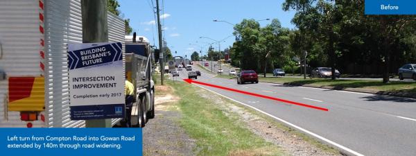
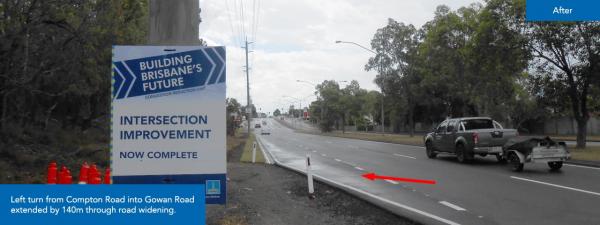
This low-cost, high-impact project was delivered in March 2017 for approximately $186,000.
Council's Bluetooth data shows this project has been successful in reducing congestion on this segment of road by measuring travel time between the intersections of Compton Road with Roosevelt Drive and Compton Road with Chateau Street.
The project has resulted in a 7% improvement in travel time for motorists using Compton Road between Roosevelt Drive and Chateau Street and travelling through past the Gowan Road intersection in the PM peak. Furthermore, traffic travelling along the same section but turning left into Gowan Street experience a 12.5% improvement in travel time during the PM peak.
Factors Affecting Network Performance
Traffic volume and travel times are also affected by other factors, including traffic incidents. These incidents, such as accidents, extreme weather and planned events, influence the amount of congestion experienced on the roads. Depending on the timing, location, severity and duration, an incident may have minimal effect on the road network or cause gridlock in large parts of the city.
Specific incidents can have a greater impact on the road network. Emergency works, for example water main repairs on the Bruce Highway, can have a significant impact on the average incident clearance times, and hence the journey times. Incidents that require emergency service attendance can take up to four hours to clear, depending on the severity and location of the incident.
Issues with trains, ferries and buses, including planned incidents and maintenance or unpredicted extreme weather events, can have a significant impact on the road network as commuters switch modes of transport. An example of this includes the planned rail line closure between Caboolture and Zillmere in September 2016 to bring the new Moreton Bay Rail Link online.
There are also locations within the city, such as Hale Street and Merivale Street, that are particularly susceptible to excess congestion when a minor incident happens. The BMTMC continues to proactively manage incidents as they happen to minimise impacts to residents, businesses and travellers within Greater Brisbane.
The data detailed in this report specifically analysed significant incidents that had the potential to have a major impact on the road network.
BMTMC collected and compiled this incident data for roads throughout the Greater Brisbane metropolitan area.
Significant incident data
This data is a collection of traffic crashes, hazards and stationary vehicles that impacted the road network. It does not cover planned events/roadworks, alerts, congestion incidents, or quick clearance towing for TMR and Council clearway towing.
Month | Number of incidents | Average duration¹ (HH:MM:SS) |
|---|---|---|
January | 332 | 00:56:49 |
February | 365 | 00:56:37 |
March | 478 | 04:06:321 |
April | 352 | 00:52:04 |
May | 363 | 00:46:28 |
June | 388 | 00:57:00 |
Average | 380 | 01:25:55 |
¹Average incident duration during March was greatly influenced by closed roads due to localised flooding.
Range of durations of significant incidents
This graph shows the range of durations¹ in minutes of significant incidents.
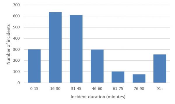
¹Incident duration is measured from the time BMTMC is notified about the incident until the time the incident is resolved (cleared from the road).